
MATHERHORN PRESS RELEASE - June 3, 2013
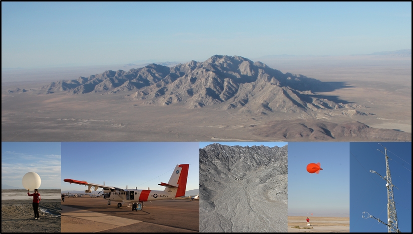 Photo collage from the Fall MATERHORN Campaign compiled courtesy of professor Stephan DeWekker, University of Virginia.
On May 31st, 2013, investigators of the Mountain Terrain Atmospheric Modeling and Observations (MATERHORN) Program successfully completed two unique field campaigns focusing on meteorological phenomena with time scales from a few seconds to hours, and covering spatial extents of tens of kilometers down to millimeters. Mountain weather can evolve dramatically over different scales, and the MATERHORN Program capitalized on its access to the Granite Mountain Atmospheric Sciences Test Bed (GMAST) of the US Army Dugway Proving Ground (DPG) to maximize these scale ranges in a sheltered, yet completely natural setting. A bevy of participants filled the GMAST with high-end instrumentation, making these two campaigns perhaps the most extensive mountain terrain field experiments conducted hitherto in terms of instrumentation and scope. The fall experiments (September 25 to October 31, 2012) focused on quiescent fair weather (wind speeds < 5 m/s) wherein diurnal heating/cooling provided main forcing. The spring study, begun on May 1 and only just completed on May 31st, dealt with larger, synoptic flow effects, moister surface conditions, and covered mostly moderate (5 to 10 m/s) and strong (> 10m/s) wind periods.
Field experiments are a key component of MATERHORN’s principle thrusts (Modeling, Experimental, Technology and Parameterization) that are symbiotically directed at improving weather predictions in complex terrain. A Multidisciplinary University Research Initiative (MURI) grant from the Office of Naval Research provides the main funding for MATERHORN, with University of Notre Dame (lead), University of California (Berkeley), Naval Postgraduate School, University of Utah and University of Virginia as grantees. A number of additional US and foreign institutions joined MATERHORN, leveraging alternative funding sources, mainly the Army Research Office and Air Force Weather Office (http://www.nd.edu/~dynamics/materhorn).
The field studies were designed using guidance from the WRF Model. Background meteorology was characterized via radiosonde launches (at 7 locations), 6 ceilometers, 3 Sodars, a Sodar/RASS, a wind profiler, two microwave radiometers, a FM/CW radar and a C-Band Doppler Radar. An array of 51 Portable Weather Instrumentation Data Systems (PWIDs), 31 Surface Atmospheric Measurement Systems (SAMS) and 51 MiniSAMS recorded the wind patterns in GMAST at kilometer and sub-kilometric scales, and two sets of tethered balloons measured the vertical profiles up to several kilometers at a meter scale resolution. Moisture was probed at km scales via two newly developed RF crosshairs (surface), microwave radiometers (vertical profiles) and infrared gas analyzers (fluxes). Three Doppler Lidars scanned dynamic regions around the mountain, each covering a hemisphere of about 1 km. At times, Lidars were coordinated to a triple Lidar mode to form virtual towers. Swaths along preferred slopes as well as a valley and canyons were instrumented with twenty sonic flux towers (10 to 32 m high), a series of 17 HOBO® weather stations and 17 Local Energy-balance Measurements Stations (LEMS). A fiber optic distributed temperature system (DTS) was deployed over a 2 km track of the most highly instrumented slope, which provided near surface measurements on meter and seconds scales. Five surface energy budget stations were deployed for evaluating land-surface schemes used for modeling. Detecting the smallest scales of turbulence that dissipates turbulent kinetic energy were two hot-wire stations, one dedicated to near surface turbulence and the other in the surface layer. High-speed IR imagery was used to characterize the effects of shadow fronts on slope flow formation and to correlate with turbulent fluxes over the desert playa. Manned Navy Twin Otter flights with Doppler Wind Lidar (TODWL) and unmanned aerial vehicles crisscrossed GMAST vertically and horizontally during selected periods. Elaborate multiple smoke releases helped visualize flow streak lines associated with the complex mountain flow physics.
Each campaign included ten Intensive Observational Periods (IOPs) where all instruments operated in coordination. The fall study included six IOPs with quiescent fair weather, the rest with moderate and strong winds. Nine IOPs of the spring experiment had either moderate or strong winds and were associated with higher moisture levels. An ensemble of numerical modeling (WRF ensembles, NAM, and GFS models) and satellite products guided the selection of IOP days via weather briefing provided by DPG forecasters.
A quick glance at data promises possible uncovering of new sub-meso phenomena triggered by flow interactions at disparate scales and even the upscale energy transfer. Although flow surrounding Granite Peak is considered nominally simple, the canonical up and down slope/valley flows existed only for short time, only to be overshadowed by those arriving from nearby mountains, basins, canyons, ravines and gullies. Overflowing cold pools from one basin to another through gaps produced expanding ‘thermal rivers’ and distorted dipolar eddies, which can be central to corridors of fog formation, turbidity and low visibility. In particular, existing meso-scale models fail to capture essentials of these interactions, as they occur in relatively thin layers, such as fronts between flows, interfaces between layers of different densities and instabilities that affect a range flow scales. Collisions of disparate katabatic flows appeared to produce enhanced shear, sporadic turbulence and even solitary waves near the ground. Katabatic currents are ‘shaved off’ by overlying skewed flows originating from nearby topographies. At times, katabatic flows were lifted above denser currents undercutting from below, and all interactions occurred on sub-kilometer scales. Thin, extremely strong, thermally forced near surface meso-scale jets developed over the west desert playa, producing intense turbulence in the lowest levels of the atmosphere. Existing flux parameterizations in models ignore such ephemeral yet energetic episodes. Synoptic flow effects may wipe out thermal flows of exposed mountains, but they cannot penetrate those in tandem, thus leaving thermal circulation in the wakes of exposed mountains relevant. As the data processing progresses, many new phenomena and parameterizations are expected to emerge, and field investigators will work synergistically with modelers to decipher mountain terrain weather intricacies and improve their predictions.
And for now, it is clear that not even simplest, loneliest mountains in nature can act alone!